

Hyderabad Metro Phase 2 Map 2026: Gachibowli & Airport Metro Routes
Hyderabad is expanding its metro rail network to improve connectivity across major residential, commercial, employment and transportation corridors.
The Hyderabad Metro Phase 2 Map covers proposed corridors beyond the existing operational metro network. The current HMRL Phase II proposal includes important areas such as Shamshabad RGIA, Kokapet Neopolis, Chandrayangutta, Patancheru, Hayat Nagar, Bharat Future City, Medchal and Shamirpet.
If you are looking for the Hyderabad Metro Phase 2 Map, a Metro Station Near Gachibowli, information about the Hyderabad Airport Metro, the Nearest Metro Station in Hyderabad, or the Hyderabad Metro Route Map, this guide explains the current and proposed connectivity.
For the existing metro network, you can also explore our detailed Hyderabad Metro Station Map to see the current stations and routes.
Hyderabad Metro Phase 2 Map
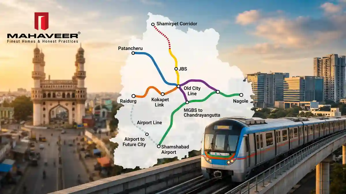
The Hyderabad Metro Phase 2 Map represents the proposed expansion of Hyderabad’s metro rail network.
According to Hyderabad Metro Rail Limited, Phase II-A consists of five proposed corridors covering approximately 76.4 km, while Phase II-B consists of three additional corridors covering approximately 86.1 km.
Phase II-A Proposed Corridors
| Corridor | Proposed Route | Length |
|---|---|---|
| Corridor IV | Nagole – Shamshabad RGIA | 36.8 km |
| Corridor V | Raidurg – Kokapet Neopolis | 11.6 km |
| Corridor VI | MGBS – Chandrayangutta | 7.5 km |
| Corridor VII | Miyapur – Patancheru | 13.4 km |
| Corridor VIII | LB Nagar – Hayat Nagar | 7.1 km |
| Total | 76.4 km |
Phase II-B Proposed Corridors
| Corridor | Proposed Route | Length |
|---|---|---|
| Corridor IX | RGIA – Bharat Future City | 39.6 km |
| Corridor X | JBS New – Medchal | 24.5 km |
| Corridor XI | JBS New – Shamirpet | 22.0 km |
| Total | 86.1 km |
These corridors are part of the proposed expansion and should not be confused with the currently operational metro lines. HMRL’s official Phase II page provides the latest published corridor information.
For the latest official project information, visit Hyderabad Metro Rail Limited – Phase II.
Hyderabad Metro Phase 2 Routes
The proposed Hyderabad Metro Phase 2 routes are planned to extend connectivity to several rapidly developing parts of the city.
The major proposed corridors include:
- Nagole – Shamshabad RGIA
- Raidurg – Kokapet Neopolis
- MGBS – Chandrayangutta
- Miyapur – Patancheru
- LB Nagar – Hayat Nagar
- RGIA – Bharat Future City
- JBS New – Medchal
- JBS New – Shamirpet
The current HMRL Phase II information identifies these as proposed corridors. The project is progressing through approvals, land acquisition, utility shifting, consultancy and implementation-related activities.
For readers interested in the current metro network rather than future expansion, visit our Hyderabad Metro Stations guide.
Metro Station Near Gachibowli
People searching for a Metro Station Near Gachibowli are usually looking for the closest operational metro station to their destination.
There is currently no operational Hyderabad Metro station named Gachibowli Metro Station.
However, Raidurg Metro Station is an important metro access point for the wider Gachibowli and HITEC City area.
The official Raidurg station information lists its location at Mindspace, HITEC City Road, and provides access toward Gachibowli, Biodiversity and IKEA from the station.
Therefore, people travelling to Gachibowli should check the exact destination before selecting their metro station.
Nearby operational metro stations can include:
- Raidurg
- HITEC City
- Durgam Cheruvu
- Madhapur
The best option depends on your destination and last-mile transportation. For official station information, see Raidurg Metro Station – L&T Metro.
Future Metro Connectivity Near Gachibowli
The proposed Raidurg – Kokapet Neopolis corridor is particularly relevant to western Hyderabad.
HMRL currently lists this as Corridor V, with a proposed length of 11.6 km. The current HMRL tender information also identifies the corridor as having 8 proposed stations.
This corridor could improve future public transportation connectivity toward:
- Raidurg
- Kokapet
- Neopolis
- Western Hyderabad growth areas
However, it is important to describe this as proposed/future connectivity, rather than as an operational metro line.
Nearest Metro Station in Hyderabad

The Nearest Metro Station in Hyderabad depends entirely on your current location.
Hyderabad’s existing operational network includes three major corridors:
- Red Line: Miyapur – LB Nagar
- Green Line: JBS Parade Ground – MGBS
- Blue Line: Nagole – Raidurg
The official Hyderabad Metro network map shows these current operational routes and stations.
If you are travelling from Gachibowli, Raidurg may be a convenient metro access point depending on your exact destination.
If you are in Kukatpally, Miyapur, Uppal, LB Nagar or other parts of Hyderabad, a different metro station may be closer.
How to find the nearest metro station
- Identify your current location.
- Search for the nearest operational Hyderabad Metro station.
- Check road distance rather than only straight-line distance.
- Check the metro route.
- Consider last-mile transportation.
- Check current metro operating information before travelling.
This also helps users searching for metro near me, nearest metro station, and metro station near my location.
Hyderabad Airport Metro
The Hyderabad Airport Metro is one of the most important proposed components of Hyderabad Metro Phase 2.
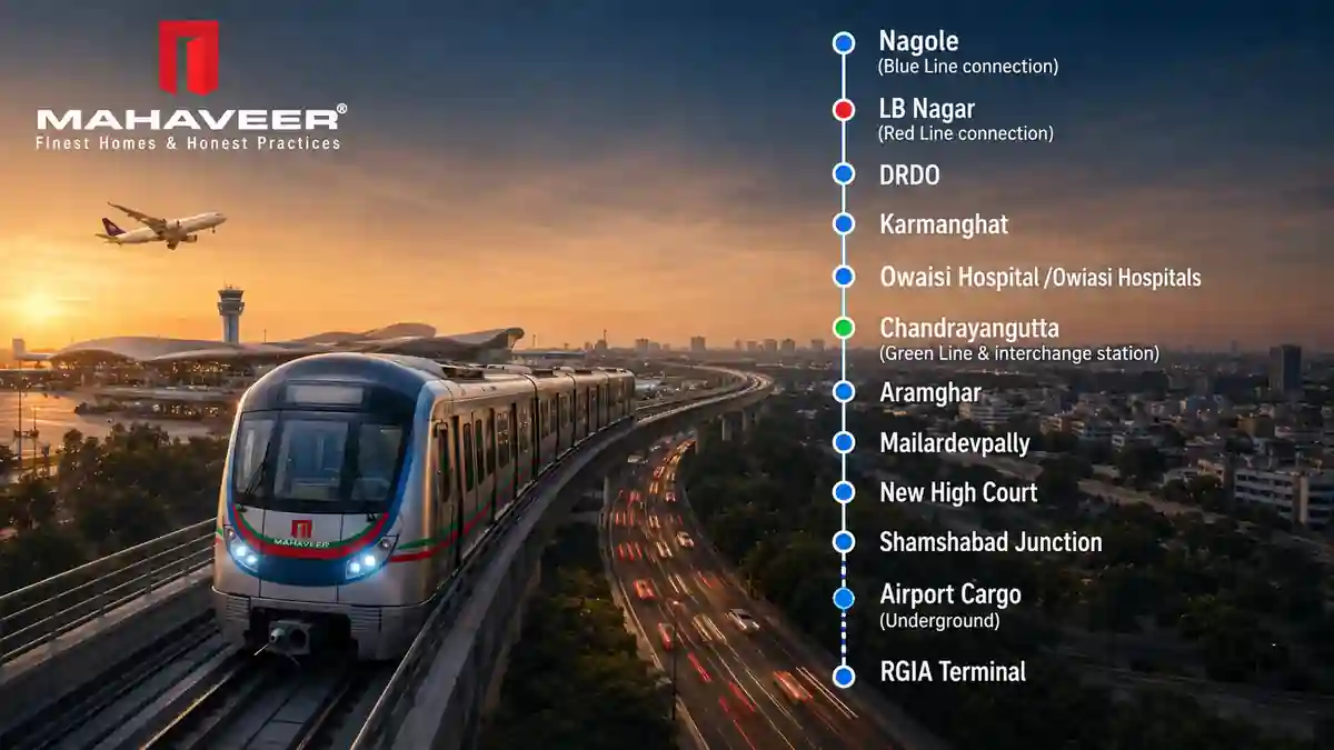
The current HMRL Phase II proposal identifies Nagole – Shamshabad RGIA as Corridor IV, covering approximately 36.8 km.
The proposed airport corridor is intended to improve future metro connectivity toward Rajiv Gandhi International Airport (RGIA).
HMRL has described the airport corridor through areas including LB Nagar, Karmanghat, Owaisi Hospital, Chandrayangutta, Mailardevpally, Aramghar and Shamshabad.
This makes the Hyderabad Airport Metro an important future transportation project for Hyderabad.
Hyderabad Airport Metro Route
The proposed airport metro corridor is:
Nagole → Shamshabad RGIA
The proposed Phase II-B network also includes:
RGIA → Bharat Future City
HMRL lists the RGIA–Bharat Future City corridor at approximately 39.6 km.
Therefore, future airport connectivity is being considered through more than one proposed corridor.
For the latest official information, Hyderabad Metro Phase II Airport Corridor.
Airport Metro Line Timing
Airport Metro Line Timing is a popular search query, but this keyword needs to be handled carefully.
The proposed Hyderabad Airport Metro does not currently have a regular operational passenger timetable. Airport metro timings will need to be confirmed through official Hyderabad Metro announcements when the service becomes operational.
For the existing Hyderabad Metro, official operational information should be checked separately.
The current Raidurg station information, for example, lists first train at 6:00 AM and last train at 11:00 PM from terminal stations.
Hyderabad Metro Route Map
The Hyderabad Metro Route Map is useful for understanding both current and future connectivity.
The existing operational network consists of:
Red Line
Miyapur → LB Nagar
Green Line
JBS Parade Ground → MGBS
Blue Line
Nagole → Raidurg
The official Hyderabad Metro network map shows the current station sequence and interchange points.
For a detailed station-by-station guide, visit our Hyderabad Metro Station Map.
Current Hyderabad Metro Map vs Phase 2 Map
It is important to distinguish between the two.
| Current Metro | Phase 2 |
|---|---|
| Operational network | Proposed expansion |
| Red Line | Nagole–Shamshabad RGIA |
| Green Line | Raidurg–Kokapet Neopolis |
| Blue Line | MGBS–Chandrayangutta |
| Miyapur–LB Nagar | Miyapur–Patancheru |
| Nagole–Raidurg | LB Nagar–Hayat Nagar |
| JBS–MGBS | RGIA–Bharat Future City |
| JBS–Medchal | |
| JBS–Shamirpet |
The official HMRL Phase II page should be used for future corridor information, while the official current network map should be used for operational routes.
Gachibowli Metro Connectivity and Real Estate
Gachibowli is an important employment and commercial area in western Hyderabad.
Current metro access is available through the Blue Line, with Raidurg being particularly relevant to the wider Gachibowli area.
Future connectivity is also important because HMRL’s Phase II proposal includes the Raidurg–Kokapet Neopolis corridor.
For property buyers, however, metro connectivity should be evaluated along with:
- Existing road connectivity
- Current metro access
- Proposed metro connectivity
- Employment hubs
- Schools
- Hospitals
- Shopping facilities
- Airport access
- Social infrastructure
A proposed metro corridor should be considered a future infrastructure factor, not an existing facility.
Mahaveer Crystal Garden – Attapur, Hyderabad
For readers interested in residential property in Hyderabad, Mahaveer Crystal Garden is a Mahaveer Constructions project located at:
Pillar No. 86, PVNR Expressway, Attapur, Hyderabad – 500028
Hyderabad Metro Phase 2: Latest Project Status
Hyderabad Metro Phase 2 is moving through various planning, approval and implementation-related stages.
In July 2026, HMRL reported that its board reviewed land acquisition, utility shifting and approval status for Phase II.
HMRL’s current tender listings also include a consultancy package covering proposed corridors including Nagole–RGIA, Raidurg–Kokapet Neopolis, MGBS–Chandrayangutta and LB Nagar–Hayat Nagar.
Therefore, this article should be updated periodically rather than treating the Phase 2 map as permanently fixed.
How to Check Hyderabad Metro Phase 2 Updates
Before making travel or property decisions based on a proposed metro route, check:
- Official HMRL announcements
- Current Phase II project status
- Official tender information
- Government approvals
- Confirmed station information
- Current construction updates
Use the official Hyderabad Metro Rail Limited website as your primary external reference.
You can also link to the official HMRL Tenders page when discussing current implementation activity.
Frequently Asked Questions
What is the Hyderabad Metro Phase 2 Map?
The Hyderabad Metro Phase 2 Map represents the proposed expansion of Hyderabad’s metro network beyond the existing operational corridors.
Which areas are included in Hyderabad Metro Phase 2?
The current proposal includes areas such as Shamshabad RGIA, Kokapet Neopolis, Chandrayangutta, Patancheru, Hayat Nagar, Bharat Future City, Medchal and Shamirpet.
Is there a Metro Station Near Gachibowli?
There is no operational station named Gachibowli. Raidurg Metro Station provides important current metro access for parts of the Gachibowli area.
What is the nearest metro station to Gachibowli?
Raidurg is an important metro station for the wider Gachibowli area, but the best station depends on your exact destination.
Is Hyderabad Airport Metro operational?
The Hyderabad Airport Metro is part of the proposed Phase II expansion. The current proposal includes the Nagole–Shamshabad RGIA corridor.
What are the Airport Metro Line timings?
The proposed airport metro does not currently have a regular operational passenger timetable. Timings should be confirmed through official announcements when the service becomes operational.
How can I find the nearest metro station in Hyderabad?
Your nearest station depends on your location. Use the current Hyderabad Metro network map together with a map application to identify the closest operational station.
What is the Hyderabad Metro Route Map?
The current Hyderabad Metro Route Map covers the operational Red, Green and Blue Lines. The proposed Phase 2 routes are separate future expansion corridors.
Will Metro Phase 2 improve Gachibowli connectivity?
The proposed Raidurg–Kokapet Neopolis corridor is intended to extend future metro connectivity toward the western Hyderabad growth corridor.
Will Hyderabad Metro connect to Hyderabad Airport?
The proposed Nagole–Shamshabad RGIA corridor is included in Phase II, while Phase II-B also includes the RGIA–Bharat Future City corridor.
Conclusion
The Hyderabad Metro Phase 2 Map 2026 provides an overview of the city’s proposed future metro expansion.
The major corridors include Nagole–Shamshabad RGIA, Raidurg–Kokapet Neopolis, MGBS–Chandrayangutta, Miyapur–Patancheru, LB Nagar–Hayat Nagar, RGIA–Bharat Future City, JBS–Medchal and JBS–Shamirpet.
For the current operational network, readers can refer to our Hyderabad Metro Station Map and Hyderabad Metro Stations guides. For future routes, readers should check the latest official HMRL updates because project details can change during approvals and implementation.