

Hyderabad Metro Station Map 2026: Route Map, Lines & Stations
The Hyderabad Metro Station Map helps commuters, residents, visitors and homebuyers understand the city’s metro routes, stations, interchange points and connectivity.
Hyderabad Metro currently operates three interconnected lines: the Red Line, Green Line and Blue Line. The Red Line connects Miyapur with LB Nagar, the Green Line connects JBS Parade Ground with MGBS, and the Blue Line connects Nagole with Raidurg.
If you are searching for a Metro Map of Hyderabad, this guide explains the current operational metro lines, Hyderabad Metro route map, major stations, interchange stations and the overall Hyderabad Metro rail network.
Hyderabad Metro Station Map

The Hyderabad Metro Station Map provides a visual overview of the operational metro network across Hyderabad.
The current network has three lines:
| Metro Line | Route | Important Areas |
|---|---|---|
| Red Line | Miyapur – LB Nagar | Kukatpally, Ameerpet, Nampally, MGBS, Dilsukhnagar |
| Green Line | JBS Parade Ground – MGBS | Secunderabad, Musheerabad, Narayanguda |
| Blue Line | Nagole – Raidurg | Uppal, Secunderabad, Ameerpet, Jubilee Hills, Madhapur, HITEC City, Raidurg |
The official Hyderabad Metro network map confirms the three operational corridors and their station sequence.
Metro Map of Hyderabad
The Metro Map of Hyderabad helps passengers identify the metro line serving their starting location and destination.
The three operational routes are:
Red Line
Miyapur → LB Nagar
Green Line
JBS Parade Ground → MGBS
Blue Line
Nagole → Raidurg
These three lines form the currently operational Hyderabad Metro network. The official operator provides the current network map and route information.
For the latest official visual map, you can also refer to the official Hyderabad Metro Network Map.
Hyderabad Metro Route Map
The Route Map Hyderabad Metro helps passengers identify routes between different stations and determine whether an interchange is required.
Red Line – Miyapur to LB Nagar
The Red Line connects northwestern Hyderabad with southeastern Hyderabad.
Important stations include:
- Miyapur
- JNTU College
- KPHB Colony
- Kukatpally
- Balanagar
- Bharat Nagar
- Erragadda
- S.R. Nagar
- Ameerpet
- Punjagutta
- Khairatabad
- Lakdi-ka-Pul
- Assembly
- Nampally
- Gandhi Bhavan
- Osmania Medical College
- MGBS
- Malakpet
- Dilsukhnagar
- Chaitanyapuri
- Victoria Memorial
- LB Nagar
The complete station sequence should be checked against the latest official network information.
Green Line – JBS Parade Ground to MGBS
The Green Line connects the Secunderabad side with central Hyderabad.
Important stations include:
- JBS Parade Ground
- Secunderabad West
- Gandhi Hospital
- Musheerabad
- RTC X Roads
- Chikkadpally
- Narayanguda
- Sultan Bazar
- MGBS
The Green Line connects with the Blue Line at JBS Parade Ground and the Red Line at MGBS.
Blue Line – Nagole to Raidurg
The Blue Line connects eastern Hyderabad with major western business and technology areas.
Important stations include:
- Nagole
- Uppal
- Stadium
- NGRI
- Habsiguda
- Tarnaka
- Mettuguda
- Secunderabad East
- Parade Ground
- Paradise
- Rasoolpura
- Prakash Nagar
- Begumpet
- Ameerpet
- Madhura Nagar
- Yusufguda
- Jubilee Hills Check Post
- Road No. 5 Jubilee Hills
- Peddamma Temple
- Madhapur
- Durgam Cheruvu
- HITEC City
- Raidurg
The official network map lists the Blue Line from Nagole to Raidurg.
Hyderabad Metro Lines
Hyderabad Metro currently has three operational lines.
Hyderabad Metro Red Line
Route: Miyapur – LB Nagar
The Red Line serves several important residential and commercial locations, including Miyapur, Kukatpally, Ameerpet, Nampally, MGBS and Dilsukhnagar.
Hyderabad Metro Green Line
Route: JBS Parade Ground – MGBS
The Green Line provides connectivity between JBS Parade Ground, Secunderabad and central Hyderabad.
Hyderabad Metro Blue Line
Route: Nagole – Raidurg
The Blue Line connects eastern Hyderabad with Secunderabad, Ameerpet, Jubilee Hills, Madhapur, HITEC City and Raidurg.
Metro Line Hyderabad Map
The Metro Line Hyderabad Map makes it easier to understand the relationship between the city’s three operational corridors.
Red Line
Miyapur ↔ LB Nagar
Green Line
JBS Parade Ground ↔ MGBS
Blue Line
Nagole ↔ Raidurg
Passengers can use the map to identify their nearest station, destination station and possible interchange.
For the most up-to-date map, refer to the official Hyderabad Metro network map.
Hyderabad Metro Rail Network Map
The Hyderabad Metro Rail Network Map provides an overall view of the city’s operational metro system.
The network allows passengers to identify:
- Metro lines
- Station names
- Terminal stations
- Interchange stations
- Major connected areas
- Nearby transport connections
- Possible travel routes
The current official map shows:
Red Line: Miyapur → LB Nagar
Green Line: JBS Parade Ground → MGBS
Blue Line: Nagole → Raidurg
Hyderabad Metro Interchange Stations
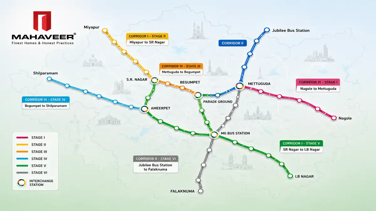
Interchange stations are particularly important because passengers can change from one metro line to another.
The current network has three major interchange points.
Ameerpet Metro Station
Red Line ↔ Blue Line
Ameerpet allows passengers to transfer between the Miyapur–LB Nagar corridor and the Nagole–Raidurg corridor.
The official L&T Metro information confirms Ameerpet as a Red Line and Blue Line interchange.
MGBS Metro Station
Red Line ↔ Green Line
MGBS connects the Red and Green Lines and is also an important transport location in central Hyderabad.
JBS Parade Ground Metro Station
Green Line ↔ Blue Line
JBS Parade Ground connects the Green and Blue Lines and provides an important interchange in the Secunderabad area.
Hyderabad Metro Stations List
If you want the complete Hyderabad Metro Stations List, we have a separate detailed article covering the stations line by line.
👉 Hyderabad Metro Stations: Complete List of Stations, Lines & Routes
That article is specifically designed for readers looking for:
- Hyderabad Metro station names
- Red Line stations
- Green Line stations
- Blue Line stations
- Station-wise information
- Stations near popular locations
- Metro routes
This separation is useful because this article focuses primarily on the map and network, while the station article focuses on the complete station list.
Metro Hyd Map – Important Stations
People also search for Hyderabad’s metro network using shorter terms such as Metro Hyd Map or Hyd Metro Map.
Some important stations to identify on the map include:
Red Line
- Miyapur
- Kukatpally
- Ameerpet
- Nampally
- MGBS
- Dilsukhnagar
- LB Nagar
Green Line
- JBS Parade Ground
- Secunderabad West
- Gandhi Hospital
- Musheerabad
- Narayanguda
- MGBS
Blue Line
- Nagole
- Uppal
- Secunderabad East
- Ameerpet
- Jubilee Hills
- Madhapur
- Durgam Cheruvu
- HITEC City
- Raidurg
The official network map should be used when checking the exact station sequence.
Hyderabad Metro Connectivity to Major Areas
Hyderabad Metro connects several important residential, commercial and employment locations.
Kukatpally
Kukatpally is served by the Red Line and is connected to stations including KPHB Colony, JNTU College and Balanagar.
Ameerpet
Ameerpet is one of Hyderabad’s major metro interchange stations, connecting the Red and Blue Lines.
Secunderabad
Secunderabad is served by both the Green and Blue Line network.
Madhapur
Madhapur is served by the Blue Line.
HITEC City
HITEC City is served by the Blue Line and is an important metro destination for Hyderabad’s technology and business district.
Raidurg
Raidurg is the western terminal of the operational Blue Line.
Hyderabad Metro Timings
According to the current official L&T Metro timetable, Hyderabad Metro operates daily.
The current published schedule states:
- First train: 6:00 AM
- Last train: 11:00 PM from terminal stations on Red and Blue Lines
- Green Line last terminal departure: 11:35 PM
Because operational schedules can change, passengers should verify the latest information before travelling.
For the latest schedule:
Hyderabad Metro Phase 2
Hyderabad Metro Phase 2 is separate from the currently operational Red, Green and Blue Lines.
HMRL’s Phase II information currently lists proposed corridors including:
- Nagole – Shamshabad RGIA
- Raidurg – Kokapet Neopolis
- MGBS – Chandrayangutta
- Miyapur – Patancheru
- LB Nagar – Hayat Nagar
- RGIA – Bharat Future City
- JBS New – Medchal
- JBS New – Shamirpet
For complete information about these proposed routes, use our dedicated article:
👉 Hyderabad Metro Phase 2 Map: Routes, Stations & Airport Metro
Metro Connectivity and Attapur
Attapur is an important residential location in southwestern Hyderabad with access to major roads and the PVNR Expressway.
When evaluating connectivity from Attapur, homebuyers should consider:
- Road connectivity
- Public transportation
- Airport access
- Railway connectivity
- Metro access
- Employment centres
- Schools and hospitals
- Shopping and daily conveniences
Do not claim that Attapur currently has an operational metro station inside the locality. Your existing article correctly makes this distinction.
Mahaveer Crystal Garden in Attapur
For readers researching residential property in Attapur, Mahaveer Crystal Garden is one of the projects showcased by Mahaveer Constructions.
The project is located at:
Mahaveer Crystal Garden
Pillar No. 86, PVNR Expressway
Attapur, Hyderabad – 500028
You can learn more about the project here:
👉 Mahaveer Crystal Garden – 3 & 4 BHK Apartments in Attapur
When comparing a residential property, metro connectivity should be considered together with road access, airport connectivity, employment hubs, schools, hospitals and other location factors.
For a broader comparison of Hyderabad property locations, visit:
Hyderabad Metro Map and Real Estate
Metro connectivity can influence how buyers evaluate a residential location, particularly when the property is close to major employment and commercial areas.
However, buyers should not evaluate a property only on the basis of metro connectivity.
Consider:
- Location
- Road connectivity
- Metro connectivity
- Airport access
- Railway access
- Employment hubs
- Schools
- Hospitals
- Shopping
- Social infrastructure
- Project amenities
- Construction quality
- Approvals and documentation
For Hyderabad property research, you can explore the other guides available on the Mahaveer Constructions real estate blog.
Frequently Asked Questions
What is the Hyderabad Metro Station Map?
The Hyderabad Metro Station Map shows the operational metro routes, stations, terminal points and interchange stations across Hyderabad.
How many Hyderabad Metro lines are operational?
Hyderabad currently operates three metro lines: Red, Green and Blue.
What is the Hyderabad Metro Red Line route?
The Red Line runs from Miyapur to LB Nagar.
What is the Hyderabad Metro Green Line route?
The Green Line runs from JBS Parade Ground to MGBS.
What is the Hyderabad Metro Blue Line route?
The Blue Line runs from Nagole to Raidurg.
Which metro station connects the Red and Blue Lines?
Ameerpet connects the Red and Blue Lines.
Which metro station connects the Red and Green Lines?
MGBS connects the Red and Green Lines.
Which metro station connects the Green and Blue Lines?
JBS Parade Ground connects the Green and Blue Lines.
Which metro line goes to HITEC City?
HITEC City is served by the Blue Line, which runs between Nagole and Raidurg.
Which metro station is useful for Madhapur?
Madhapur Metro Station is on the Blue Line. Depending on the exact destination, Durgam Cheruvu, Peddamma Temple or HITEC City may also be relevant.
What time does Hyderabad Metro start?
The current official timetable lists the first train at 6:00 AM.
What time does Hyderabad Metro close?
The current published timetable lists the last terminal departures at 11:00 PM for the Red and Blue Lines and 11:35 PM for the Green Line. Check the official timetable before travelling.
Where can I find the latest Hyderabad Metro map?
The latest network information is available from the official Hyderabad Metro network-map page:
Conclusion
The Hyderabad Metro Station Map provides a convenient way to understand Hyderabad’s current operational metro network.
The network consists of three lines:
- Red Line: Miyapur – LB Nagar
- Green Line: JBS Parade Ground – MGBS
- Blue Line: Nagole – Raidurg
Ameerpet, MGBS and JBS Parade Ground are important interchange stations connecting the three corridors.
For the latest route and station information, readers should refer to the official Hyderabad Metro network map and timetable.
If you want a complete station-by-station reference, visit our Hyderabad Metro Stations guide.
For proposed expansion corridors, read our Hyderabad Metro Phase 2 Map guide.
For residential property research in Attapur, explore Mahaveer Crystal Garden.