

Rapid Metro Map 2026: Route, Panvel Metro & India Metro Network
Metro rail has become one of the most important public transportation systems in India’s growing cities. From Hyderabad and Delhi-NCR to Mumbai, Bengaluru, Chennai and other major urban centres, metro networks are helping connect residential areas, business districts, transportation hubs and developing corridors.
The Rapid Metro Map is particularly useful for understanding the metro system serving the Gurugram area, while the Panvel Metro is a separate metro-related development in the Mumbai Metropolitan Region.
This guide explains the Rapid Metro Map, Rapid Metro Route Map, Panvel Metro Route and Metro Rail Network in India, while also comparing these systems with major metro networks across the country. For readers interested specifically in Hyderabad, see our detailed Hyderabad Metro Station Map to explore the current Hyderabad Metro network.
Rapid Metro Map
The Rapid Metro Map shows the metro system serving Gurugram and its connection with the Delhi Metro network.
Rapid Metro Gurgaon was developed to provide connectivity within important commercial and residential areas of Gurugram and to connect with the Delhi Metro network.
The Rapid Metro system operates through stations serving areas such as:
- Cyber City
- Sikanderpur
- DLF Phase 2
- DLF Phase 3
- Moulsari Avenue
- Sector 42-43
- Sector 53-54
- Sector 54 Chowk
- Sector 55-56
The system is particularly relevant for commuters travelling between Gurugram’s business districts, residential communities and the Delhi Metro interchange at Sikanderpur.
For official information about Rapid Metro services, routes and stations, readers should check the Delhi Metro Rail Corporation official website.
Rapid Metro Route Map
The Rapid Metro Route Map helps commuters understand the route, stations and interchange points within Gurugram.
A major advantage of Rapid Metro is its connection with the wider Delhi Metro network.
Sikanderpur is particularly important because commuters can interchange between Rapid Metro and the Delhi Metro network.
The Rapid Metro corridor provides access to major employment and commercial locations in Gurugram, including areas around Cyber City and DLF developments.
Why Rapid Metro is useful
Rapid Metro can help commuters:
- Travel within Gurugram
- Access commercial areas
- Connect with Delhi Metro
- Reduce dependence on road transport
- Reach major employment hubs
- Connect residential and business areas
Because metro routes and operating information can change, readers should check the latest official information before travelling.
Rapid Metro Stations
Rapid Metro serves important locations across Gurugram.
Some of the key stations include:
- Sikanderpur
- DLF Phase 2
- DLF Phase 3
- Moulsari Avenue
- Cyber City
- Belvedere Towers
- Phase 2
- Sector 42-43
- Sector 53-54
- Sector 54 Chowk
- Sector 55-56
The exact station list and operational information should be verified against the latest official metro information. If you are looking for information about metro stations in Hyderabad, read our Hyderabad Metro Stations guide.
Rapid Metro and Delhi Metro
Rapid Metro is closely connected with the Delhi Metro system through Sikanderpur.
This connection is important because commuters can use the wider Delhi-NCR metro network after transferring from Rapid Metro.
For someone travelling within Gurugram, the Rapid Metro can provide convenient access to commercial and residential areas, while the Delhi Metro provides broader regional connectivity.
For the latest Delhi Metro network, fares, stations and operating information, use the official Delhi Metro Rail Corporation website.
What Is Panvel Metro?
The Panvel Metro refers to proposed/planned metro connectivity associated with Panvel and the wider Mumbai Metropolitan Region.
Panvel is strategically important because it is a major transportation and development hub in the Mumbai Metropolitan Region.
The area is connected with major transportation infrastructure including:
- Panvel railway station
- Mumbai–Pune Expressway
- Sion–Panvel Highway
- Navi Mumbai International Airport region
- Developing residential areas
- Industrial and commercial zones
Because metro planning around Panvel can involve different projects and phases, always verify the current status, alignment and station information from official Maharashtra government and MMRDA sources.
For Mumbai Metropolitan Region transport planning and metro projects, use the official Mumbai Metropolitan Region Development Authority website.
Panvel Metro Route
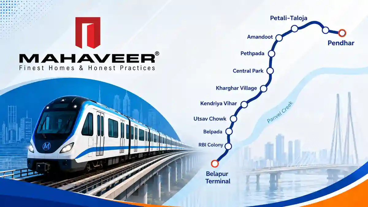
People searching for Panvel Metro Route are generally looking for information about proposed metro connectivity around Panvel and Navi Mumbai.
Panvel is an important node in the Mumbai Metropolitan Region because of its railway connectivity, highway network and proximity to the Navi Mumbai International Airport.
However, it is important to distinguish between:
Existing railway connectivity
and
proposed metro connectivity.
Do not present a proposed Panvel Metro route as an operational metro service.
For the latest project information, readers should verify the current route and project status through official authorities.
Panvel Metro and Real Estate Growth
Panvel has attracted significant attention from homebuyers and developers because of its strategic location within the Mumbai Metropolitan Region.
When evaluating property in Panvel, buyers should consider:
- Railway connectivity
- Highway connectivity
- Airport access
- Employment centres
- Educational institutions
- Healthcare facilities
- Shopping and entertainment
- Current infrastructure
- Proposed infrastructure
- Project approvals
Future metro infrastructure can be one factor in evaluating a location, but buyers should not rely exclusively on a proposed metro project.
Metro Rail Network in India
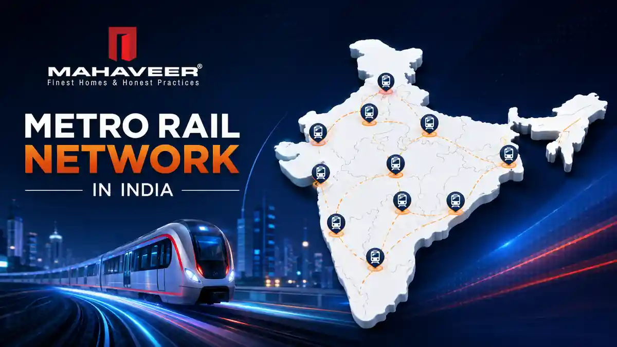
The Metro Rail Network in India has expanded significantly as cities invest in mass rapid transit.
Metro systems are operating or being developed across several Indian cities, including:
- Delhi
- Hyderabad
- Mumbai
- Bengaluru
- Chennai
- Kolkata
- Kochi
- Jaipur
- Nagpur
- Pune
- Ahmedabad
- Lucknow
- Kanpur
- Noida
- Gurugram
Each city has its own metro network, routes, stations, expansion plans and operating arrangements.
For Hyderabad readers, our Hyderabad Metro Station Map provides a more detailed look at Hyderabad’s current network.
Major Metro Networks in India
India’s metro systems serve different transportation needs depending on the city.
| City | Metro System | Main Purpose |
|---|---|---|
| Delhi-NCR | Delhi Metro | Regional urban connectivity |
| Hyderabad | Hyderabad Metro | Hyderabad urban connectivity |
| Mumbai | Mumbai Metro | Mumbai Metropolitan Region |
| Bengaluru | Namma Metro | Bengaluru urban connectivity |
| Chennai | Chennai Metro | Chennai urban connectivity |
| Kolkata | Kolkata Metro | Kolkata metropolitan connectivity |
| Jaipur | Jaipur Metro | Jaipur urban connectivity |
| Kochi | Kochi Metro | Kochi urban connectivity |
| Ahmedabad | Ahmedabad Metro | Ahmedabad-Gandhinagar region |
| Lucknow | Lucknow Metro | Lucknow urban connectivity |
| Nagpur | Nagpur Metro | Nagpur urban connectivity |
| Pune | Pune Metro | Pune urban connectivity |
This comparison is useful for readers researching the broader metro rail network in India.
Hyderabad Metro and the Indian Metro Network
Hyderabad is an important part of India’s expanding metro network.
The operational Hyderabad Metro currently includes:
Red Line
Miyapur – LB Nagar
Green Line
JBS Parade Ground – MGBS
Blue Line
Nagole – Raidurg
For a detailed list of operational stations, visit our Hyderabad Metro Stations article.
For the complete current map, see our Hyderabad Metro Station Map.
Hyderabad Metro Phase 2
Hyderabad’s future metro expansion is also important when discussing India’s growing metro rail network.
The proposed Phase II corridors include connectivity toward areas such as:
- Shamshabad RGIA
- Kokapet Neopolis
- Chandrayangutta
- Patancheru
- Hayat Nagar
- Bharat Future City
- Medchal
- Shamirpet
For readers specifically researching future Hyderabad Metro connectivity, read our dedicated Hyderabad Metro Phase 2 Map guide.
Rapid Metro vs Hyderabad Metro
Rapid Metro and Hyderabad Metro are different metro systems.
| Feature | Rapid Metro | Hyderabad Metro |
|---|---|---|
| Location | Gurugram | Hyderabad |
| Network purpose | Gurugram connectivity | Hyderabad urban connectivity |
| Delhi Metro connection | Yes | No |
| Major employment areas | Gurugram | HITEC City, Madhapur and other areas |
| Network | Smaller system | Larger city network |
| Future expansion | Subject to official plans | Phase II proposals |
The comparison demonstrates how different Indian cities have developed metro systems based on their local transportation requirements.
Panvel Metro vs Hyderabad Metro
Panvel and Hyderabad represent different stages and types of metro development.
Hyderabad already has an operational metro network, while proposed metro connectivity around Panvel should be checked against the latest official project information.
For property buyers, transportation infrastructure can influence location decisions, but it should be evaluated together with existing connectivity and other infrastructure.
How Metro Networks Help Indian Cities
Metro rail systems can provide several benefits.
1. Reduced Road Congestion
Mass transit allows large numbers of passengers to travel without using individual vehicles.
2. Better Public Transportation
Metro networks provide structured transportation corridors within busy urban areas.
3. Employment Connectivity
Metro stations can connect residential areas with major employment centres.
4. Improved Accessibility
Metro systems can make important areas easier to reach without depending entirely on private vehicles.
5. Support for Urban Development
Metro corridors can become important components of long-term city planning.
Metro Connectivity and Real Estate
Metro infrastructure is often considered when people evaluate residential and commercial property.
However, buyers should differentiate between:
Operational Metro Connectivity
and
Proposed/Future Metro Connectivity.
An operational station provides current transportation access.
A proposed metro corridor represents potential future connectivity and may be subject to changes in alignment, approvals, timelines and implementation.
Therefore, property buyers should consider:
- Current metro station distance
- Road connectivity
- Public transportation
- Airport connectivity
- Employment hubs
- Schools
- Hospitals
- Retail
- Project location
- Legal approvals
- Developer reputation
- Future infrastructure
Mahaveer Crystal Garden – Attapur, Hyderabad
For readers researching residential property in Hyderabad, Mahaveer Crystal Garden is a Mahaveer Constructions project located at:
Pillar No. 86, PVNR Expressway, Attapur, Hyderabad – 500028.
If you are researching residential property locations in Hyderabad, explore our Real Estate Locations in Hyderabad guide to compare different areas and their connectivity.
How to Check the Latest Metro Route Information
Metro projects can change because of:
- Government approvals
- Alignment changes
- Land acquisition
- Construction requirements
- Station changes
- Funding
- Project phases
Therefore, readers should check official sources before making travel or property decisions based on a proposed metro route.
For Delhi-NCR metro information, use Delhi Metro Rail Corporation.
For Mumbai Metropolitan Region infrastructure, use MMRDA.
For Hyderabad Metro information, use Hyderabad Metro Rail Limited.
Frequently Asked Questions
What is the Rapid Metro Map?
The Rapid Metro Map shows the metro route and stations serving Gurugram, including connections with the wider Delhi Metro network.
What is the Rapid Metro Route Map?
The Rapid Metro Route Map shows the Rapid Metro corridor, stations and interchange connectivity in Gurugram.
What is Panvel Metro?
Panvel Metro refers to proposed/planned metro connectivity associated with Panvel and the wider Mumbai Metropolitan Region. Current route and project status should be checked with official authorities.
What is the Panvel Metro Route?
The Panvel Metro Route refers to planned metro connectivity involving Panvel and surrounding areas. The exact route and implementation status should be verified using current official project information.
Which cities have metro rail networks in India?
Major Indian cities with metro systems include Delhi-NCR, Hyderabad, Mumbai, Bengaluru, Chennai, Kolkata, Jaipur, Kochi, Ahmedabad, Lucknow, Nagpur and Pune, among others.
Is Rapid Metro connected to Delhi Metro?
Yes. Rapid Metro has an interchange connection with the Delhi Metro network at Sikanderpur.
Does Hyderabad have a metro network?
Yes. Hyderabad has an operational metro network consisting of Red, Green and Blue Lines, with additional expansion proposed under Phase II.
What is the Hyderabad Metro Route Map?
The Hyderabad Metro Route Map shows the city’s current operational metro corridors and stations. You can see the detailed map in our [Hyderabad Metro Station Map] guide.
Is Panvel Metro operational?
The status of proposed Panvel-related metro projects can change. Check the latest official information from the relevant Maharashtra authorities before describing a route as operational.
Why is metro connectivity important for real estate?
Metro connectivity can improve access to employment centres, commercial areas and other parts of a city. However, buyers should evaluate current and proposed connectivity separately.
Conclusion
The Rapid Metro Map is useful for understanding Gurugram’s dedicated metro connectivity and its relationship with the wider Delhi Metro network.
The Panvel Metro is a separate metro-related development associated with the Mumbai Metropolitan Region, while Hyderabad, Delhi-NCR, Mumbai, Bengaluru, Chennai and other cities have their own metro systems.
Together, these developments demonstrate the continuing growth of the Metro Rail Network in India.
For Hyderabad-specific information, readers can explore our Hyderabad Metro Station Map, Hyderabad Metro Stations and Hyderabad Metro Phase 2 Map guides to understand current and future metro connectivity.